What is a Geofence?
At its core, a geofence is a virtual perimeter mapped around a real-world geographic area. For fleet managers, it transforms a static map into a dynamic monitoring tool. The system actively monitors whether a vehicle or asset has crossed this border, logging “in” or “out” events in real-time.
These automated logs empower you to generate precise operational reports, receive instant alerts, and configure specific behavioral rules within designated areas—such as receiving speeding alerts strictly when a vehicle operates within city limits or a defined depot zone.
The Value of Spatial Awareness
Understanding how your fleet interacts with key locations drives efficiency. Whether you are monitoring time spent at a customer site or ensuring vehicles do not leave a secure yard out of hours, geofences automate the oversight.
- Automated Entrance & Exit Logging
- Location-Specific Alert Rules
- Detailed Time-on-Site Reporting
The Three Shapes of Security
Not all operational zones are created equal. Fleet Track provides three distinct geofence types to ensure you have the precise tool for every scenario, from simple depots to complex urban delivery routes.
◉
Circular
A geographic area with a defined center point and a circular shape. Offers rapid setup with a minimum radius of 50 meters. Best for general point-of-interest monitoring like supplier yards or central hubs.
⬡
Polygonal
An arbitrary polygon defined by up to 500 vertices. Essential for creating complex boundaries that match irregular real-world areas like specific neighborhoods, construction sites, or irregularly shaped parking lots.
☍
Route
A continuous virtual perimeter built along a path between multiple points. Features a customizable radius to monitor adherence to planned routes and instantly detect unauthorized deviations.
Selecting the Right Shape
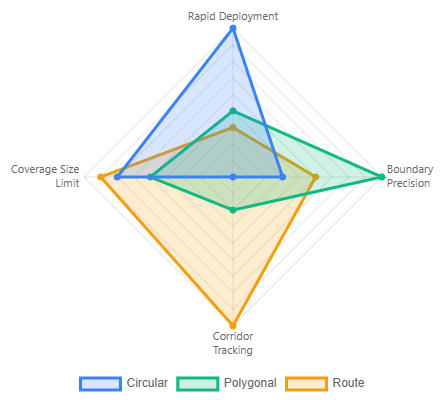
The radar chart illustrates the strengths of each type.
- Use Circular fences for rapid, broad coverage.
- Switch to Polygonal when boundary precision is non-negotiable.
- Deploy Route geofences specifically when path compliance is critical for security or service level agreements.
From Monitoring to Mastery
Geofencing is the bridge between raw GPS data and actionable business intelligence. By moving beyond simple “dots on a map” and implementing these spatial rules, you transition from reactive tracking to proactive management.
The strategic advantage lies in the automation of accountability. Whether you are protecting high-value assets with Circular perimeters, proving service delivery via Polygonal site logs, or enforcing fuel efficiency through Route compliance, you are effectively digitizing your operational standards.
The Fleet Track Advantage: Precision in your virtual boundaries leads to precision in your bottom line. Avoid the trap of “alert fatigue” by selecting the shape that mirrors your real-world constraints. Start with your highest-impact locations—your depots and your top-tier client sites—and build a digital ecosystem that works while you sleep.